
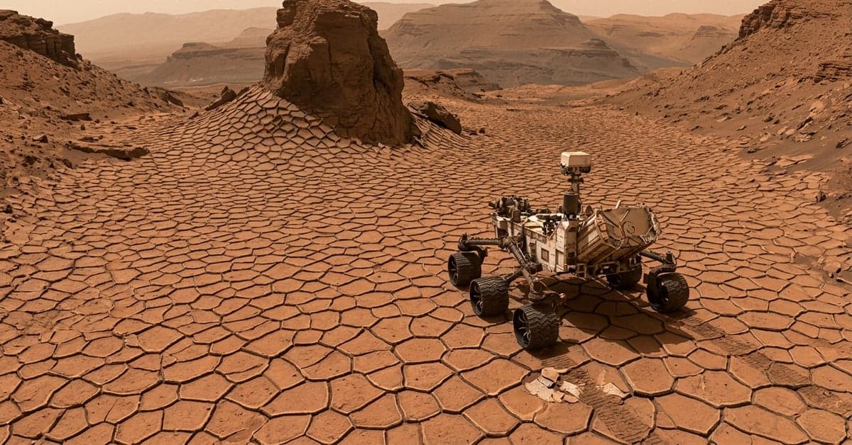
August 1, 2026 — NASA’s Curiosity rover has driven into a valley paved with tiny, polygon-shaped fractures that look like a honeycomb. According to ScienceDaily, the patterns are only inches wide yet sprawl across the terrain and even wrap around a nearby 20‑foot‑tall feature. The scale and coverage make the Curiosity honeycomb Mars scene one of the rover’s most striking textural finds.
What the Curiosity honeycomb Mars terrain looks like
The report describes a “sea” of repeating polygons, each bounded by thin ridges. They appear tightly packed, with rims that persist as the pattern bends around obstacles. That bend is key. It hints the cracking propagated through a continuous layer, then met the taller feature and kept going around it. For mission geologists, that geometry reads like a process snapshot preserved in rock.
Curiosity has seen fractured bedrock before, but the density and uniformity here stand out. The small, regular cells suggest a surface that broke under evenly distributed stresses, not isolated impacts. Even at a few inches across, the network blankets enough ground to trace patterns across slopes and flats. That continuity gives scientists multiple vantage points to test how the fractures formed.
The rover’s instrument suite is built for exactly this kind of puzzle. Cameras document textures at several scales. Contact tools sample chemistry and mineral clues at the fracture walls and the surrounding bedrock. As the team plans follow-up, each frame can be cross-checked against context from Curiosity’s decade of stratigraphy work in Gale Crater and Mount Sharp, outlined by NASA’s mission pages for Mars Science Laboratory (MSL overview).
How polygonal cracks form — lessons from Earth and Mars
Polygonal networks arise when a surface layer repeatedly shrinks and breaks. On Earth, classic mudcracks form as wet sediment dries, contracts, and fractures into hexagon-like cells. Over time, sediments fill the cracks and can turn the pattern into raised ridges after erosion reverses relief. Encyclopaedia Britannica’s entry on mud cracks walks through that cycle and its telltale shapes (mud crack basics).
There’s another path. In cold climates, freeze–thaw cycles produce polygonal ground as ice wedges grow and shrink. NASA’s Earth Observatory has detailed permafrost polygons seen from orbit in the Arctic, with veins of ice or sand outlining cells that can span meters to tens of meters (polygonal ground explained). Those patterns look similar from above but reflect different physics and timescales.
Mars complicates both stories. Thin air and a dry, cold environment can preserve delicate textures for millions of years. Once a crack opens, mineral-rich fluids may cement the edges, locking the shape in place long after the original driver fades. That preservation potential is why geologists pay attention when they see small, regular polygons on ancient Martian lakebeds. If these fractures formed in drying mud, they hint at repeated wet–dry cycles. If they formed in cold soils, they point to freeze-driven cracking. Either way, the physics carries climate clues.
The ScienceDaily report notes polygons only “a few inches wide,” underscoring the fine scale of the network. On Earth, permafrost polygons typically run far larger. Desiccation polygons often fall in the inch-to-foot range. Size alone won’t settle the case on Mars, but it narrows the shortlist of processes. So will chemistry at the fracture rims, which can betray fluids that later cemented the pattern.
Why this field matters for Gale Crater’s timeline
Gale Crater chronicles a long shift from rivers and lakes to drier, wind-shaped plains. Curiosity has worked that timeline layer by layer on the lower slopes of Mount Sharp, piecing together episodes of standing water, calm deposition, and later erosion. NASA’s science summary for MSL outlines how clay-rich and then sulfate-rich strata mark changing water availability in the crater’s interior (MSL science focus).
Where do these polygons fit? If the network proves to be ancient mud cracks, it would strengthen the case for intermittent wetting and drying on the lake margins or floodplains. That pattern supports chemistry that concentrates organics and encourages certain prebiotic reactions. If the polygons instead match freeze–thaw signatures, that would support cooler intervals when shallow ground ice expanded and contracted near the surface. Either outcome tightens the climate bounds on the rock layer Curiosity is exploring.
The way the pattern wraps around a 20‑foot‑tall feature adds a twist. That continuity suggests the fracture layer existed before erosion sculpted the taller structure. In practice, the team can use that relationship to sort out which came first: the cracking or the carving of the local topography. Those relative ages matter when reconstructing the sequence of climates that shaped Gale.
The Curiosity honeycomb Mars field also offers a calibration target. Repeating, inch-scale features let the team test how lighting, dust, and viewing angle affect texture detection. That experience feeds forward to orbital surveys and to other rovers, improving how mission planners spot similar sites from afar.
What the team may check next on the honeycomb terrain
Expect close imaging of crack intersections and rims. Junctions often record the order in which cracks formed. If one set cuts another, the sequence can reveal how stresses rotated or changed through time. The rover’s hand lens imager can capture those details at millimeter scale.
Chemistry comes next. Spectrometers can compare minerals inside the cracks, along the rims, and in the host rock. Differences can flag fluids that flowed along the fractures or cemented them later. If salts or sulfates concentrate at the edges, that leans toward drying and evaporation. If the chemistry aligns with ground ice scenarios, the team will see that, too.
Geometry matters as well. Measuring cell sizes, shapes, and any preferred orientations can separate drying polygons from freeze-driven networks. On Earth, desiccation often yields near-hexagonal, fairly regular cells. Ice-wedge polygons can be more variable and link to subtle slopes or drainage. Similar checks on Mars are possible with stereo imaging and careful mapping along Curiosity’s path.
All of this analysis happens against a familiar backdrop. Curiosity has cataloged mudstones, cross-bedded sands, and sulfate-bearing layers during its long climb. That archive gives context to every new outcrop. It’s one reason a texture as eye-catching as this can move beyond a pretty picture to a testable climate story.
What the Curiosity honeycomb Mars find tells us now
ScienceDaily’s report offers the essential facts: the location within a valley, polygon cells a few inches wide, and coverage that bends around a 20‑foot‑tall feature. From those details alone, the most likely origins point to shrinkage cracking in wet sediments or freeze–thaw cycles in ground ice. Both mechanisms have well-studied fingerprints on Earth, and both can be preserved by mineral cements on Mars. The next rover passes will sort the contenders by texture and chemistry.
The bigger implication sits with Gale Crater’s climate arc. A widespread network of small polygons embedded in lakebed rocks would favor intermittent surface water and repeated drying. A freeze–thaw match would support colder episodes with near-surface ice. Either outcome sharpens the environmental window during which the host rocks formed. And that, in turn, refines where and how Curiosity searches for habitable conditions.
As images and spectra arrive, expect NASA to relate them to prior work across Gale and beyond. Resources like the MSL mission overview (mission overview) and background explainers on polygonal ground and mud cracks help frame what comes next. For now, the Curiosity honeycomb Mars scene is more than a visual surprise. It’s a compact, testable clue to how water, ice, and time reshaped a once-habitable crater. For more on this, see bloomberg.com and nytimes.com.
Related reading: Hugging Face • Fine-Tuning • Open Source AI